Monthly Archives: August 2012

Hiatus

Well, I accomplished the main goals of interest for this trip.  I tested out my equipment, travelling kit, riding skills, endurance.  While many things worked out well, I was disappointed in my endurance towards the end.  Two 20 mile days?  Bleah!

I was happy that my packing list worked as well as it did.  I was happy that I didn’t get sick and have to figure out how to manage any emergencies, large or small.

For the next trip, I could take less clothing (or more correctly, reduce the duplication and add items of varying warmth).  Exception: more socks.  A second set of footwear is a good idea but sandals/flip flops would do the trick.

My rear pannier set was destroyed (both sides) but the trip saved, thanks to the miracle of duct tape.

Observations:

  • It was a challenge, but I did it.
  • Consecutive travel days are harder than independent travel days. Daily travel distance doesn’t seem to relate well to exhaustion level.  I didn’t mind wind (or even rain) that much but hills are really difficult.
  • Chicken trucks really stink.
  • A computer with route mapping and a GPS were worth the weight and trouble.  In fact, crucial.
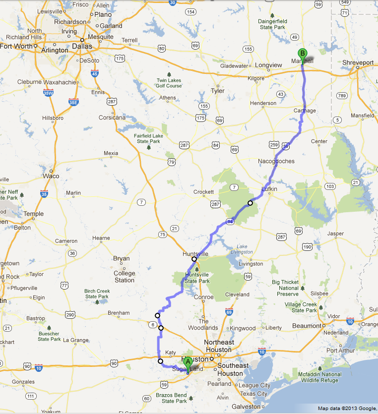
  • I should have picked several better cycling routes (and in the future will).  Some of the paved, well marked highways were a bit dangerous (hwy 30, 94, 999).  Hwy 59 was very busy but was actually a very good cycling highway.  One of the best was hwy 105.
  • There was a lot of variation in the amount of debris on the side of the road, which could not be predicted by software, Google images or reasoning.  More debris -> more flat tires.  I think I had 4 flat tires in ~315 miles.
  • Greyhound Bus turned out to be very amenable to bike transportation – that is the way to do the return trip.  I have also since taken Amtrak (not with bike) from Houston to California, and I see from their own posters and publications that they are hostile to bikes and bike riders.  Within California, they have bike oriented commuter trains, but not the long distance trains.
  • Looking ahead, it seems that a major challenge on long distance trips will be in crossing rivers.  Most bridges seem to be on interstate highways or narrow high speed highways.  More later…
  • My amateur logistical efforts worked out.
  • Definitely for the next trip: state map, GPS, cell phone, duct tape, spare tubes, armored tires.
  • [Addendum: I traveled the route from home to Huntsville a second time since the dates listed here.  They took a really nice highway between Anderson and Roans Prairie (yay!) and added chip seal to it (boo!).]


Advertisement

Day 10

Wed 2012/08/29

Start mileage 5041.9 end 5046.2 daily 5.4 trip 311.9

Route: hotel to Marshall bus station.

The weather forecast calls for strong headwinds 15-25 mph (Hurricane Isaac) in the afternoon as I proceed North, followed by an 80% probability of heavy rain for 2 days. Checking outside, the wind seems to be solid 20 mph already. I plan for several actions: (1) proceeding North to the next small town (with a questionable hotel where I will have to hole up for 2 days), (2) stay in this hotel for 3 days (3) bus home (or elsewhere). I notice that there is a bus station in Marshall. I also note that there is a bike shop, where I might be able to get a bike packing box etc. If I take the bus, I figured that they would accept me without problems but I don’t know their packaging expectations for the bike.  I programmed waypoints on the GPS for the bus station, bike store and the next town.  I checked the bus schedule on the web, and without deciding what I will do, I put on my street clothes (ie. not cycling jersey/shorts), check out of the hotel and head for the bus station.  I get a flat tire on the way, and push the bike the last 3+ miles to the bus station, without fixing the flat tire.

The bus station says that they have seats to Houston, and will take the bike as is. Problem solved; I get a ticket to Rosenberg, which is a better choice than central Houston or Houston SW (59 near Hillcroft). I arrive at the Rosenberg drop off point just before sunset, fix the flat tire but get a cab home rather than ride the bike in the dark.  I arrive home in Sugar Land about 20:30.

Day 9

Tue 2012/08/28

Start mileage 5016.4 end 5041.9 daily 25.536 trip 306.5

Route: Carthage to Marshall Best Western.

I struggled a lot on this segment. I’m not sure why but something is just hammering me. Many breaks; the first after only 4 miles or so. Wind is disorganized, coming from every direction (but strong/gusty). Solid headwind for the last 5 miles.

At ~5 mile point going over a bump, spokes catch the other (left) pannier, tear it open. Duct tape repair again. Really glad I brought that stuff.

Lunch ~13:00+ at gas station just 0.5 miles from destination (quart of milk and a sandwich), at I-20 intersection. Nap 15:00-18:50. Steak and hash browns at Waffle House. Yum.

Mileage (measured) is probably about a mile short from actual; I traveled about a mile with the odometer off.


Day 8

Mon 2012/08/27

Start mileage 4960.5 end 5016.4 daily 55.818 trip 281.0

Route: Nacogdoches to Carthage Best Western.

I was able to pump up tires properly at a bike store that I spotted next to Steven F Austin University (“SFA”). My portable bike pump will only give me about 65 pounds pressure (need 100 to do it right).  I asked a few directions (the staff on duty didn’t seem to know much about the area), and traveled on.

I am completely drained. Headwinds and hills at start. Rain and more rain. Several breaks at country churches for rain.

Pizza and milk for lunch at 15:00+ at a gas station in Gary TX (“Gary City”?) while I waited out a little questionable weather.  When it seemed to be good going, I left.

A detour on hwy 10 south of Carthage (North of Gary) forced me from Gary via hwy 999 back to hwy 59, an additional 4 miles or so. Heavy rain started on hwy 999, about 10 minutes away from Gary.  Flat (front) tire and more heavy rain on hwy 59.  My sunglasses fog up in the rain, and I am almost blind going down some hills on 59, with fast traffic to my left.  A lot of debris on the shoulders to avoid (also, a cause of flat tires).

Everything is soaking wet when I arrive at the hotel.

I anticipate headwinds and rain from hurricane Isaac soon. The Republican convention has worked around it and sent it on my way. I might have to quit around Texarkana because of the weather on the way.

There are a lot of chicken farms today and I have passed at least a couple of Tyson chicken processing plants. A lot of the traffic on these back roads is chicken trucks. They smell bad – empty or loaded. In the rain, they are nothing less than vile. The spray from passing vehicles stays with you. Yuck.

Day 7

Sun 2012/08/26

Start mileage 4941.6 end 4960.5 daily 18.945 trip 225.1

Route: Lufkin to Nacogdoches Best Western, mostly by way of Hwy 59 (across the street from my favorite Nacogdoches seafood restaurant).

Good wide shoulders, but most of the route is chip seal.

Very hard getting started. The route seemed to be more downhill than up, slight tail wind for the second half. Arrived exhausted after only 18.9 miles…

Checked in at 11:15, napped to 15:00+, lunch at seafood restaurant.

I again seemed to be quite dehydrated, drinking ~3 liters after arrival. I need to figure this out better.  Only 19 miles?  I’m not feeling very good about my capabilities.  I probably should have gone on further.

Day 6

Sat 2012/08/25

Start mileage 4885.8 end 4941.6 daily 55.769 trip 206.2

Travel: Trinity to Lufkin Super 6 Inn (ex-Motel 6).

Hwy 94 is a really bad highway for bicycling. It has chip seal most of the way, with varying shoulder size from 6 inches (ie. “nothing”) to 8 feet. Most of it is high speed single lane with 6 inch shoulder and a lot of debris.  In this part of the state, there are a few chicken farms, and tractor-trailer transports hauling chickens to a few Tyson plants in the area.  These trucks really smell bad (empty or full), and travel very fast.

The hotel I planned for in Lufkin (Storybook Inn) did not exist, and I had to continue on another ~5 miles inside Lufkin loop to the “Motel 6” per my GPS (which also doesn’t exist any more, but is now a Super 6 Inn).  My GPS is not perfect, but this is the first day when it saved me a considerable amount of trouble.

Four cars honked at me today. One after passing, one which dipped into the shoulder and honked about 10 feet behind me, 1 car full of kids in Apple Springs who threw something at me (missed). One short toot after passing might have been a guy I talked to for a while at the Apple Springs Exxon/Subway. He had recently purchased an old panel truck to pull the engine and install into his dune buggy (and trash the truck).

About 5 miles of tail wind; mostly cross wind.

Day 5

Fri 2012/08/24

Start mileage 4864.9 end 4885.8 daily 20.877 trip 150.4

Travel: Huntsville to Trinity.

Chip seal most of the way.

It is day 5 and the first day of the trip that actually had a tail wind, for about 5 miles.

Coming into Trinity, I sensed that the front tire was losing pressure, and I pedaled really hard at the end to avoid having to stop and change a tire on the road.

Today I only planned on 21 miles because I am staying in hotels each night and the next hotel is likely beyond my comfort zone.  Despite the short mileage, I feel challenged about the distance for some reason.

When I get to the hotel, I realize that I am quite dehydrated and didn’t recognize it until I was in the room, when I drank a full bottle of water without thinking about it.


Day 4

Thu 2012/08/23

Layover day 0 miles

I have had a few tough travel days, and even though the weather is nice for travelling, I decide to hang out in Huntsville for a day to work on bike and equipment repairs, route planning and related computer activities. I had a nice “Atkins” lunch and dinner at the Bandera Grill next door.

Day 3

Wed 2012/08/22

Start mileage 4822.4 end 4864.9 daily 42.523 trip 129.5

Route: Navasota to Huntsville Econo Lodge.

At departure in the morning, I left, encouraged that the main purpose of the trip was fulfilled, and didn’t fuss about the daily logistical details.  Anything I did from here on was interesting, but additional achievement beyond the goals of the trip.  Hmmm … did I set my goals too low?

About 5.5 miles into trip, the pannier is a little loose, and the right side is caught in the rear spokes, tearing the bag open. Repairs made on the side of the road.  Hooray for duct tape.

At the hotel in Huntsville, the crickets in and around the hotel were awful.  They were in the passageways, the pool, and a couple made it into the room.

Head/cross wind most of the trip.

Day 2

Tue 2012/08/21

Start mile 4769.9, end 4822.4 daily 52.538 trip 87.0

Travel: Brookshire to Navasota Best Western via hwy 362.

I had never travelled hwy 362 North of hwy 290 before; this is the start of the “new stuff” for me.  This part of the highway varied between good wide shoulders and none, nice flat pavement and chip seal.  There were a number of hills North of hwy 290 that I wasn’t expecting.  I finished my water, and was resting on the side of the road when a guy in an SUV stopped.  I told him I was a bit thirsty but was otherwise okay.  I asked about any stores on the road ahead (one, about 10 miles).  He left, I travelled on, and we met again at the junction with FM 2, when he returned with 2 bottles of water he had obtained from somewhere.  It turns out he was a coach/trainer for a Texas A&M University women’s sports team and he was traveling with the women for an event somewhere.  While we chatted at the corner of hwy 362 and FM 2, 2 a couple of maroon buses full of student athletes rounded the corner with some razzing – I’m not sure if this was directed at him or me.  Yay TAMU.

A few miles later was the store (Whitehall, TX). A light lunch, rest, water, then head on out!

Highway 105 is a very nice road for cycling – smoothly paved with a nice wide shoulder.

There was still a light head or cross wind for most of the trip.

There were even more dead frogs on the road.

I had a minor collision with a pickup truck (~5 mph) at a gas station just before the day’s stopping point (corner of hwy 105 and 6).

The hotel was nice, and a welcome sight after 52 miles of pedaling.  There was a nice steak restaurant nearby where I had a good “recovery” meal.  Doing 52 miles is a considerable accomplishment for me.

Day 1

Mon 2012/08/20

Start mile 4735.4 end 4769.9 daily 34.488 trip 34.488

Travel: Home to Brookshire Executive Inn. Hwy 362 from Pecan Grove/Plantation blvd.

I fixed a flat rear tire at 9.98 miles in, on hwy 90A in the construction barrels at Harlem Rd exit lane (third flat this year on this stretch of hwy). I am only getting 65 pounds pressure from the cheapo portable pump; Memo to self: try to get a real air pump somewhere…

Light headwind from Fulshear to Brookshire.

No conventional roadkill on the highway, but for some reason, there are a large number of dead toads/frogs on the highway, and a weird light odor that I don’t recall from previous trips.  Whatever, I can handle it.

This trip was about 1+ miles longer the last time I did it; I must have stopped somewhere last time or done some sort of loop or something…

I had previously done all of this part of the trip on my own twice before, so wasn’t expecting any surprises.  I was a bit nervous from starting this trip on my own with no backup or support, but the fact that I had done this segment before made it much easier on the soul.


August 2012 Cycling Trip

In early 2012, I wanted to go on a relatively short, unsupported cycling trip on my own. In August 2012, it became a reality, when I rode my bike from home in Sugar Land, TX to Marshall, TX, which was 320 miles away by the route I took.

RouteMapIn August 2012, I departed on my cycling trip somewhere “North and/or Northwest”.  I had never done this kind of thing before, and wasn’t sure what to expect.  Really, it was a sort of dry run for perhaps a longer trip if I discovered that I enjoyed myself and didn’t encounter any disasters or showstoppers.  I’d done about 4000 miles of cycling on my road bike either unsupported/by myself, or on rides up to 100 miles a day, which were supported/part of a group.  I planned a route, but didn’t have a specific finish line in mind. I determined that if I made it past 100 miles and 2 nights that it was a success.  Anything after that was additional accomplishment/bragging rights.

When I left home in Sugar Land, I had the following tentative plans/goals:

  • Mission success was reaching Navasota by day 2. I tentatively targeted Memphis, TN as final “dream” destination. If I did that really well (ha ha), then I would proceed further north. I had no idea how I would get home (trip completion, emergency or otherwise) or where I was going to end up. Travel choices for the return trip seemed to be (1) ride back, (2) rent a car one way (3) Amtrak or bus (4) benevolence of friends (5) drop/sell the bike and fly back.
  • I planned on staying the first night in a hotel in Brookshire, 35 miles away.  I’d ridden my bike and stayed here twice before, connecting with organized club rides out of Brookshire (the organized part of the past ride started in Brookshire; I rode the 35 miles there myself and stayed in a hotel before/after the organized part).  I had subsequent overnight spots picked out as contingencies and would select the next one based on how much mileage I could muster.
  • Planned daily travel: 20 to 60 miles a day, primarily determined by hotel location.  I have read from other people’s blogs that a reasonable day on a multi-day trip is 35 to 65 miles per day (excluding all the extreme trips and super-fit athletes).  I am not an athlete by any measure and not in the greatest shape.  I set my sights lower right to start off with.  If I did better than expected, I could revise my standards upwards. I figured that this was much more realistic and less humbling than overestimating and revising downward.
  • I observed that for long distance travel by bicycle, a better strategy is country roads and small towns.  There is a lot more trouble when you get near larger cities.  Travel within a city is downright dangerous.
  • If I was going to travel great distances, the route challenge was going to be getting around large cities, and crossing rivers. Most river crossings are on major highways, built to accommodate high speed vehicles, and not bicycles or pedestrians.
  • I have sleep apnea and need electricity overnight. For this trip, all nights would be spent in hotels. No tent, sleeping bag or camping gear (even as backup).

Enough of all of that.  On with the ride!
Day 1